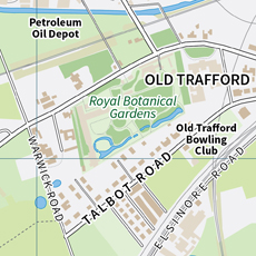
A series of three maps showing the urban development of Salford during the course of the last 120 years.

Salford

A series of three maps showing the urban development of Salford during the course of the last 120 years.

Contains Ordnance Survey data © Crown copyright and database right 2021. Map data © OpenStreetMap contributors, data available under the Open Data Commons Open Database License (ODbL).

A section of the map detailing an area of Old Trafford in 1905.

A section of the map detailing an area of Old Trafford in 1905.

A closer look at a section of the present day map, focussing on the Salford Quays area.

A closer look at a section of the present day map, focussing on the Salford Quays area.

Salford

A series of three maps showing the urban development of Salford over the course of the last century and more. These maps were produced for an educational resource pack, exploring change in the urban environment and represent the landscape in 1905, 1950 and the present day.

Designed for school use, these maps utilise a modern design but are, in the main, based upon historical Ordnance Survey maps.

Salford, in Greater Manchester (UK), has undergone major change during the course of the last century and more. Following on from the industrial revolution of the 18th and 19th centuries, the Manchester Ship Canal (completed in 1894) enabled further industrial growth, as Salford developed into a major inland port. During the late 19th and early 20th Century, industrial development, especially in the textile industries, led to economic prosperity and urban growth. Then, after the decline of that industrial base, during the great depression and on in to the post war period, there was hardship and economic decline. Amongst the social deprivation, many regeneration schemes were launched during the course of the latter half of the 20th Century. Intensive regeneration occurred in Salford and surrounding areas, during the first decade of the 21st Century, leading to the development of many new housing schemes, arts and leisure facilities and MediaCity UK - now home to several broadcasting companies, including the BBC and ITV.

These maps help to illustrate the changes in landuse within the context of a resource pack, designed for secondary school students, for use in the study of urban geography.

Maps on page contain data © OpenStreetMap contributors. Contains Ordnance Survey data © Crown copyright and database right 2021.

Ed Merritt
View Ed Merritt's profile on LinkedIn

About

Hello, my name is Ed Merritt. I am a cartographer based in Southampton (UK). I established Merritt Cartographic in 2006.

I am a graduate of Oxford Brookes University, receiving an honours degree in Mapping and Cartography. Having worked in the past for a large publishing company in central London, much of my current work is commissioned for inclusion in reference books. I also produce interactive maps for deployment on websites and in applications as well as products for use on public display panels and signposts. As a freelance cartographer, I have produced custom maps and graphics for a wide range of publishers, charities, media organisations and businesses. My work has been included in books published by Dorling Kindersley, National Geographic, Pearson, Penguin Books, Oxford University Press, Taschen, Laurence King Publishing, Millennium House and Weldon Owen. I've also created maps for a wide range of other companies and charities, including the Royal Horticultural Society, Smithsonian Institution, Best Western, The Greenbrier Companies, Fastmarkets, Bright Horizons, London & Partners and Cycling UK.

I enjoy being creative in my work and like to explore new approaches. As a map-maker, I have a natural tendency to pay attention to detail and also to work hard to ensure that I am being as accurate as I can in the work that I produce.

For more information on how Merritt Cartographic can best assist you with your project, please send me a message or make contact via the information displayed above and throughout the site. I look forward to hearing from you.

Information Button
Exit Button
Phone: +44 (0)7843 978646